


Upper Valley 3 Voting District, Weber County, Utah
About
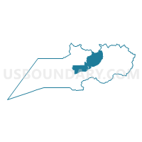
Outline

Summary
| Unique Area Identifier | 680613 |
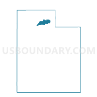
| Name | Upper Valley 3 Voting District |
| County | Weber County |
| State | Utah |
| Area (square miles) | 51.71 |
| Land Area (square miles) | 51.71 |
| Water Area (square miles) | 0.00 |
| % of Land Area | 99.99 |
| % of Water Area | 0.01 |
| Latitude of the Internal Point | 41.30366230 |
| Longtitude of the Internal Point | -111.79880780 |
Maps

Graphs
Select a template below for downloading or customizing gragh for Upper Valley 3 Voting District, Weber County, Utah


Neighbors
Neighoring Voting District (by Name) Neighboring Voting District on the Map
- Canyon Voting District, Weber County, UT
- Huntsville 2A Voting District, Weber County, UT
- Lake 2 Voting District, Weber County, UT
- North Ogden 02 Voting District, Weber County, UT
- Ogden 02 Voting District, Weber County, UT
- Ogden 03 Voting District, Weber County, UT
- Ogden 15 Voting District, Weber County, UT
- Ogden 16 Voting District, Weber County, UT
- Unpopulated Voting District, Cache County, UT
- Upper Valley 1 Voting District, Weber County, UT
- Upper Valley 2 Voting District, Weber County, UT
Top 10 Neighboring County Subdivision (by Population) Neighboring County Subdivision on the Map
- Ogden CCD, Weber County, UT (208,109)
- Ogden Valley CCD, Weber County, UT (6,604)
- East Cache CCD, Cache County, UT (105)
Top 10 Neighboring Place (by Population) Neighboring Place on the Map
- Ogden city, UT (82,825)
- North Ogden city, UT (17,357)
- Wolf Creek CDP, UT (1,336)
- Liberty CDP, UT (1,257)
- Eden CDP, UT (600)
Top 10 Neighboring Unified School District (by Population) Neighboring Unified School District on the Map
- Weber School District, UT (148,422)
- Ogden School District, UT (82,814)
- Cache School District, UT (64,634)
Top 10 Neighboring State Legislative District Lower Chamber (by Population) Neighboring State Legislative District Lower Chamber on the Map
- State House District 5, UT (43,319)
- State House District 7, UT (35,074)
- State House District 8, UT (32,064)
Top 10 Neighboring State Legislative District Upper Chamber (by Population) Neighboring State Legislative District Upper Chamber on the Map
Top 10 Neighboring 111th Congressional District (by Population) Neighboring 111th Congressional District on the Map
Top 10 Neighboring Census Tract (by Population) Neighboring Census Tract on the Map
- Census Tract 2101, Weber County, UT (6,942)
- Census Tract 2002.03, Weber County, UT (4,926)
- Census Tract 2002.04, Weber County, UT (4,592)
- Census Tract 2006, Weber County, UT (4,176)
- Census Tract 9801, Cache County, UT (105)